Life in Medieval Monaghan

Map of the escheated counties of Ireland 1609 South Ulster (The Queens University of Belfast Map Collections)
LIFE IN MEDIEVAL MONAGHAN
It is interesting to try to get a picture of what life was like in our own area of mid-Monaghan in medieval times – who were the people who lived here? how did they live, work, eat, dress, socialize, interact with the world around them etc.?
The old Gaelic way of life which had existed with little change for several hundred years was disrupted and changed forever around 1600 AD. The Norman invasion of the 12th century was the beginning of the English colonization and conquest which gradually over the centuries changed Ireland. Monaghan was one the last places to feel the brunt of those changes. Throughout the 1500s Monaghan was still McMahon Country. Three McMahon chieftains – in Farney, Dartry and Monaghan and McKenna in Truagh ruled over subordinate septs and clans, basically under Brehon Law and Irish customs. They fought the old fights with each other and sometimes made peace, sometimes war, with the overbearing O’Neill to their north and the English in the Pale to the south.
Livingstone observes:
“Even in the second half of the sixteenth century many of the Irish chieftains did not seem to realise that there was a conquest in progress at all. Among these were the McMahons. They did not see that the English presence in Ireland was aiming at the complete conquest of the whole nation and the replacement of one way of life by another. Nor did they see that the English conquest would ultimately abolish their rights, their privileges, their laws, their customs and their culture. In addition, the fact that the conquerors aimed at substituting the Protestant religion for their own Catholic faith does not seem to have troubled them. The aims of the McMahons were more immediate….They wanted to be left alone”.

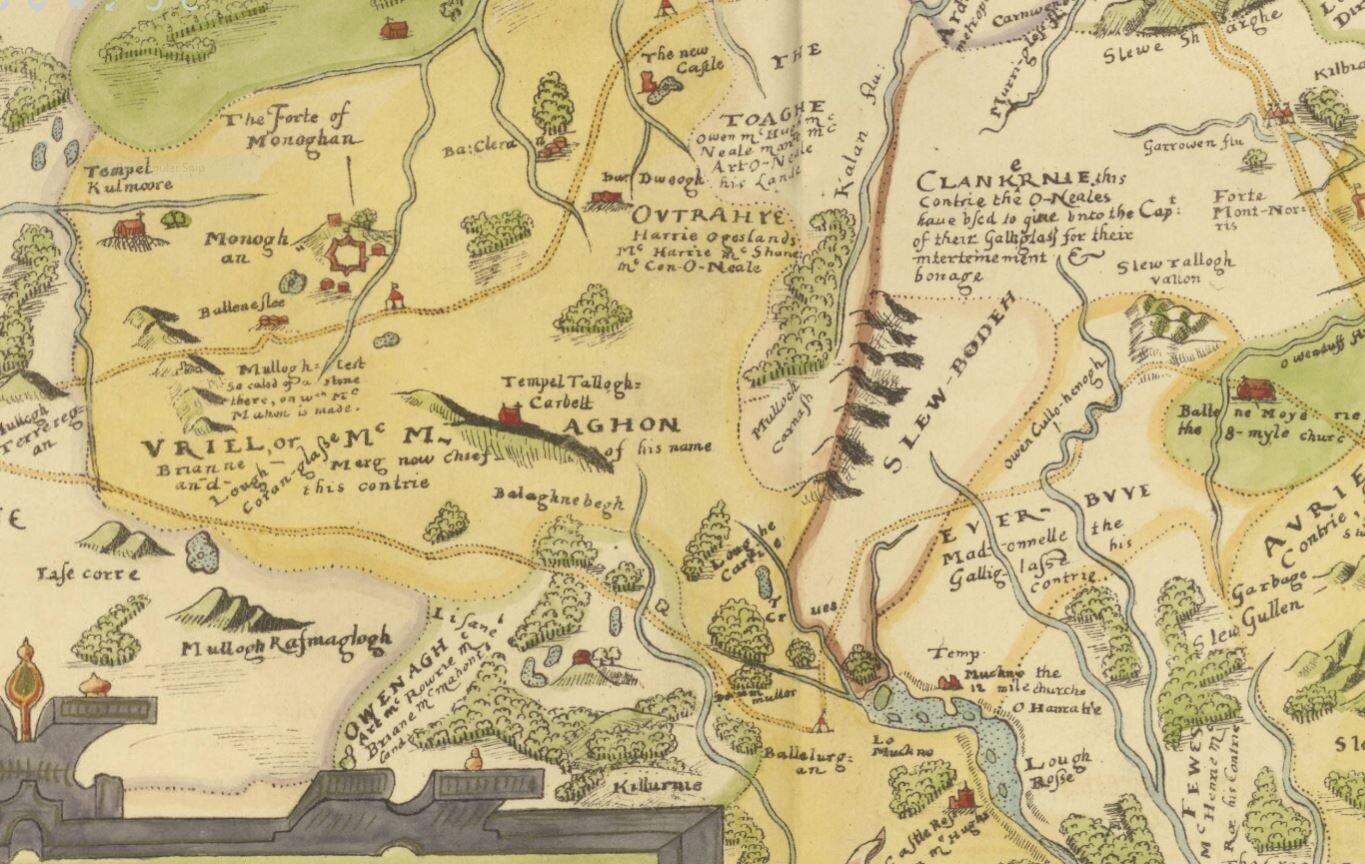
Map of the escheated counties of Ireland 1609 Monaghan (The Queens University of Belfast Map Collections)
Who were the people who made the population of mid-Monaghan in the sixteenth century?
While we do not have lists of names of individuals we can be sure that they were families of Duffys, Connollys, Mohans and Moens, Boylans, Brennans, McArdles, McNallys, Cassidys, Kellys, Hughes, McEneaneys etc.; in other words families which are still most numerous in Clontibret and Castleshane. Most of them would have been residents of the same territories for generations before, evolving from the occcupiers of the hill-top ringforts identified in the map above. Many of the family names are incorporated into the old land denominations of ballybetaghs. Examples of this are ballybetaghs of Ballyvickenally, Ballymcskeaghan, Ballymorphie.
How did they live and work and survive?
Historians, officials reporting to government and contemporary commentators provide us with a vast amount of information. Of historians, for examples, Fr Peter Livingstone in The Monaghan Story has a very detailed history and genealogy of The McMahons and PJ Duffy of Maynooth University (and Annyalla) in his various writing has given a very thorough exposition on the landscape of the county including reconstructions of ballybetaghs and tates. And there are many other eminent local historians whose scholarly work is readily available in, for instance, the journals of the Clogher Historical Society. The ecclesiastic history of the diocese of Clogher is also, of course, thoroughly documented. What is most difficult to find is reliable writings which describe the everyday life of the ordinary rural dwellers in medieval times.
The problem is that such accounts as there are mostly biased and, in fact, diametrically opposed, depending on whether the writer has a Gaelic perspective or a British one. The idealized romantic picture of the land of saints and scholars flowing with milk and honey and populated with comely maidens and athletic warriors was often painted by sycophantic poets and bards glorifying their Gaelic overlords who sustained them.
From early medieval times the role of the bardic poets had been central to Gaelic culture. All prominent chieftains retained and patronized “learned families” who composed poems in praise of their chieftains and who, in return, were rewarded with land and other material wealth. Certain families held this role for generations. In Monaghan, the most prominent “learned family” connected to the McMahon chiefs was the Mac an Bhaird (Ward) family. A detailed study: “Bardic Poetry and the MacMahons of Oirghialla” by Nioclás Mac Cathmhaoil can be found in Monaghan History and Society (Geography Publications 2017)
On the other hand, most of the English commentators, particularly from Tudor and Elizabethan times, had a vested interest in demonizing the native Irish and condemning them as ignorant savages needing to be civilized, or even exterminated.
The following extracts from Irish History from Contemporary Sources (1509 – 1610) by Constantia Maxwell illustrates the widely divergent pictures of Ireland presented at the time:

John Speed Map of Ireland 1611 (UCS Map Collection)
Extract from Fynes Moryson’s Itinerary 1617:
The wild, and as I may say “mere” Irish…are barbarous and most filthy in their diet. They scum the seething pot with a handful of straw, none of the cleanest, and strain their milk through a like handful of straw and so cleanse, or rather more defile the pot and milk. They devour great morsels of meat unsalted…and all these pieces of flesh, they seethe in a hollow tree, lapped in a raw cow’s hide and so set over the fire and therewith swallow whole lumps of filthy butter….they willingly eat the herb Shamrock, being of a sharp taste, which as they run and are chased to and fro, they snatch like beasts out of the ditches…..When they come to any market town to sell a cow or a horse, they never return home till they have drunk the price in Spanish wine, or in Irish “usquebaugh”.
These wild Irish never set any candles upon tables; what do I speak of tables? Since indeed they have no tables, but set their meat upon a bundle of grass….but I mean they do not set candles on any high place to give light to the house, but place a great candle made of reeds and butter upon the floor in the midst of a great room, the smoke whereof goeth out at a hole in the top thereof.
I trust no man expects among these gallant any beds, much less feather beds and sheets, who like the nomads removing their dwellings, according to the commodity of pastures for their cows, sleep under the canopy of Heaven, or in a poor house of clay, or in a cabin made of the boughs of trees and covered with turf, for such are the dwellings of the very lords among them. And in such places, they make a fire in the midst of the room and round about it they sleep upon the ground, without straw or other thing under them, lying in a circle about the fire…and their bodies being naked, they cover their heads and upper parts with their mantles.
From Thomas Churchyard’s poem The Fortunate Farewell to…the Earl of Essex (1599)
The sons of shame and children of God’s wrath
With wolfish minds like breechless bears they go
Through woods and bogs and many a crooked path;
Lying like dogs, in litter, dung and straw,
Rude as brute beasts that know no rule or law……..
Account of Don Francisco Cuellar from Adventures to Connacht and Ulster (1589)
The custom of these savages is to live as the brute beasts among the mountains….They live in huts made of straw. The men are all large-bodied and of handsome features and limbs and as active as the roe deer…They clothe themselves with tight trousers and short loose coats of very coarse goats’ hair. They cover themselves with “mantas”(blankets)…..
The chief inclination of these people is to be robbers and to plunder each other…for the people in one village becoming aware that in another there are cattle or other effects, they immediately come armed in the night and kill one and other….they sleep upon the ground, on rushes, newly cut and full of water and ice.
The most of the women are very beautiful, but badly dressed. They do not wear more than a chemise, and a blanket with which they cover themselves, and a linen cloth, much doubled, over the head and tied in front.
The great majority of their churches, monasteries and hermitages have been demolished by the English and of those natives who have joined them and are as bad as they. In short in this Kingdom there is neither justice nor right and everyone does what he pleases.
Description by William Camden in 1586:
The air is unfit for bringing corn to maturity but so productive of vegetables, not only rank but even sweet, that if the cattle feed but small part of the day they will fill themselves….hence it is that they have an infinite quantity of cattle, it being their principal wealth; and also many flocks of sheep, which they shear twice every year, and of the coarse wool make mantles or rugs exported to foreign parts. They also have excellent horses, which we call “hobbies”….their hawks likewise are in no small repute…..Here are such quantities of bees that they are found not only in hives but in trunks of trees and holes of the earth. In short, whether we consider the fruitfulness of the soil, or the convenience of the sea or ports, or the inhabitants, who are warlike, ingenious, comely, extremely soft-skinned and from the tenderness of their muscles exceedingly nimble, the island is in many respects so highly favoured that Giraldus said, not without reason, “Nature beheld this realm of Zephyr with an uncommonly favourable eye”.
Description by Lord Mountjoy in 1601:
That it may please her excellent Majesty of this her Kingdom of Ireland, that it is one of the goodliest provinces of the world, being in quantity or quality little inferior to her realm of England, breeding a people of excellent temper……abounding with all the sustenance of life, as corn, cattle, fish and fowl; for inbred riches as mines for divers sorts of metals, and salts, quarries of ordinary stones and rich marbles; for means by foreign traffic to be enriched, as divers excellent havens and navigable rivers.
……that it has been far otherwise than it is, the ancient privileges of towns, the huge ruins of great buildings in them, and the likes of churches and monasteries, bishops’ seats and laymen’s castles and inhabitations, doth declare.
Account of Edmond Campion 1633
The people are this inclined; religious, frank, amorous, ireful sufferable of pains infinite, very glorious, many sorcerers, excellent horsemen, delighted with wars, great almsgivers….. They are sharp-witted, lovers of learning, capable of any study whereunto they bend themselves…..they speak Latin like a vulgar language, learned in their common schools of leechcraft and law, whereat they begin children, and hold on sixteen or twenty years conning by rote the Aphorisms of Hippocrates, and the Civil Institutions……..I have seen them where they kept school, ten in some one chamber, groveling upon couches of straw, and their books at their noses, themselves lying flat prostrate, and so to chant out their lessons, being the most part lusty fellows of twenty-five years and upwards.
Geoffrey Keating (Seatrun Ceitinn) wrote Foras Feasa ar Eirinn, (translated as History of Ireland) in the early 1600. In the introduction to Foras Feasa he makes scathing comment on foreigners, like those quoted above, who wrote about Ireland. In an unforgettable simile he refers to them as dung beetles:
“For it is in the fashion of the beetle, when it lifts its head in the summer time, to go about fluttering, and not to stoop toward any delicate flower that may be in the field, or any blossom in the garden..but it keeps bustling about until it meets with dung of horse or cow and proceeds to roll itself therein.”
Marshal Bagnal’s Description of Ulster 1586:
The County of Monaghan containeth these countries: Uriel, Dartree, Loughtee and Trough. The chief captain thereof is one Sir Rory McMahon, who hath been sometime contributory to Tirlough O’Neill and now is left to the government of the Earl of Tyrone, yet of himself is very desirous to yield only to the Queen, and to be governed after the English manner. He is able to make of his own nation, and other his followers, 100 horsemen and 400 footmen. Buildings in his country are none, save certain old defaced monasteries.

Taylor & Skinner 1777 (UCD Map Collection)
From Report by the Lords Justices and Council of Ireland to Secretary Vane in April 1641 on The Plantations:
The County of Monaghan was, in Queen Elizabeth’s reign, regranted, after a title had been found, to the old owners, in the same disordered manner as they formerly held. Soon after they went into rebellion, and to this day the county is the most barbarous, poor and despicable in the kingdom, the Earl of Essex’s lands excepted, where several English dwell, and except the Lord Blayney and his family.
End of the McMahon ownership of Monaghan and of the Gaelic way of life.
The 1591 division of Monaghan was the end result of the government's policy of abolishing landholding by Gaelic law or hybrids of English and Irish law. Short of confiscation and plantation, such a policy involved the elimination of the concept of Gaelic overlordship, the implementation of the crown's sovereignty over the land and the establishment of inheritance by primogeniture under English law. In Monaghan confiscation was minimal in 1591, except in the case of termon lands which being outside secular Gaelic control, were generally granted to government nominees. Mensal lands also became technically available to the government Apart from some relatively minor alterations aimed at the establishment of lords' estates of roughly equal size it may be assumed fairly confidently that the 1591 survey is an adequate reconstruction of the shape and structure of the Gaelic landholding system in Monaghan. Because of the war in Ulster and the involvement of some of the Monaghan families, it was necessary to reactivate the settlement in 1606. (Duffy)
1n 1585 the county of Monaghan came into being, divided into the five Baronies of Farney, Cremorne, Dartry, Monaghan and Truagh. A scheme for the division of the county between the leading McMahon chieftains was devised by the Lord Deputy, Sir William Fitzwilliam – with the exception of termon land which was granted to various English people – and was put in place in November 1591.
The lands were allotted to the McMahon chiefs
Patrick Dubh – most of Clontibet and Tehallen
Evar Mc Con Uladh – around Castleblayney and part of Clontibret
Brian Mc Hugh Og – the Barony of Dartry
Patrick Mc Art Moyle –in Monaghan Barony
Ross Ban – in Monaghan Barony
Brian Og – part of Truagh Barony, around Glaslough
And Patrick McKenna - the remainder of Truagh (from Livingstone)
From Shirley
TOWNLANDS IN THE LUCAS ESTATE: Parish of Clontibret
E.S. Lucas in 1880s Allotted in 1591 to: “disposed” in 1640 to:
Aghnameal
Annagh
Annahuby Hugh McMahon
Arclintagh
Ballygreany Ld Blayney
Carrickanure Sir Henry Brooks
Clarderry id
Clerran Sr St John Broderick
Clonaneor
Cordevlis
Corlagan Nth.
Corlagan Sth.
Corleanamaddy Lord Massareen
Cornamucklagh N.
Cornamucklagh S.
Coryloan
Creeve
Crossaghy Dr Thomas Wyatt
Dernaglug
Derryarrilly
Dooskey Peter Beagan Dr Thomas Wyatt
Downs
Dromore Sr St John Broderick
Drumgallan Peter Beagan
Dromgolat Toole mcPhelym Lord Massareen/FrancisLucas
Drumgristin
Drumnart
Feddans Brian McHugh Roe McMahon Lord Massareen
Fintully
Glennyhorn Gilduffe McEvar McMahon Dr Thomas Wyatt
Greenmount Art McHugh Roe McMahon Francis lucas/Peter Beagan
Latnakelly Sir Henry Brooks
Letteragh
Letterbane
Lisaginny
Lisglassan Sir St John Broderick
Lismagunshin Lord Massareen
Lisnagreeve James Hamilton
Listroar
Moy Etra Edmond Carragh McOwen Ld Broderick
Moy Otra ditto Ld Massareen
Moysnaght
Mullagarry Gilduffe McEvar McMahon Richard Morrish
Mullans Dr Thomas Wyatt
Pullans Dr Thomas Wyatt
Tirmacmoe Symon Richardson
Tullycumaskey Hugh Roe McMahon Dr Thos Wyatt
From Shirley
TOWNLANDS IN THE LUCAS ESTATE: Parish of Monaghan
E.S. Lucas in 1880s Allotted in 1591 to: “disposed” in 1640 to
Ballycronog John Fleming
Castleshane Demesne ?Rev. John Symonds
1656 – Mary Lucas
Corlust John Fleming
Cordevlis
Creeve John Fleming
Edenbrone
Feebane
Lattigar
Lismenan
Tiravray
Parish of Tehallen
Aghabrick
Carrowkeel Art McHugh McEvar McMahon
Cordevlis James Garlon
Coraskealy James Garlon
Corrrawillin James Garlon
Garron Otra Art McGilpatrickMcEvar McMahon
Kingorry Collo McEvar McMahon

Down Survey Map 1640 - the Barony of Cremorne (LBrown Map Collection)
Names of ballybetaghs obviously derived from names of families who held tracts of land under the over-lordship of a Mc Mahon and it is notable that some of the names enshrined in them are family names still common in the area: Murphy, Mc Skeane, Mc Nally. In the Hearthmoney Rolls of 1643, a Tige Fearty is listed in Castleshane which was in the ballybetagh of Ballyfeartie.
While the ballybetagh disappeared from use about end of the 17th century (?), the ancient townland/tates are still with us, surprisingly little changed in name or composition. The Down Survey and Book of Distribution 1640 lists Proprietors in 1640, denomination of lands and in some cases to whom disposed (i.e. leased or confiscated and re-allotted ?) The ballybetagh in which tates are located is also given.
The information on ballybetaghs and tates within them, available from the various sources is of particular interest as it enables us to compare present townland names with 17th century tate names and to speculate, with some degree of certainty, on the location of placenames that have disappeared from use.
One half of the ballybetagh of Ballyfertie was in the ownership of The Heiress of Mr. John Symonds, Prot. The tates listed are
Tyrebrewey ?
Agheterefeaghan ? Tiravray
Sian Castleshane Demesne
Aghmacmorigan
Leamnagory A Lucas Estate map of Corlust shows an area bordering Annaglough as "known As Lemnagory"
Aghanaglogh Aghnaglough
Tyrelonma ?
Lismenan Lismenan
The only other current townland name here of which we would expect trace is Lattygar.a townland of just 30 acres between Lismenan and Edenbrone (which is listed in Ballymurphy ballybetagh).Presumably the tates of Tyrebrewey, Aghmacmorigan and Tyrelonma became part of Castleshane Demesne.
The other half of Ballyfertie was in the ownership of Christopher Fleming I.P. (Irish Papist?) and disposed to Jam, Fleming:
Corlaskedemy 2 tates ? Corlust?
Corlatdargan ?
Creave Creeve
Ballycronoge Ballycranog
Legnacreave Legnaceeve
Lisnamcgh ?
Dromegrenan ?
The only current townland name missing in this section appears to be Corrinshigo, which may correspond to Lisnamcgh or Dromegrenan. It is likely that Corlatdargan, like Lemnagory in the top section, became subsumed into Castleshane Demesne.
The 16 tates in the ballybetagh of Ballymurphy were accounted for as follows:
The Heiress of John Symonds was proprietor of
Edenbrone
Crevorchie Cormurphy?
Corduflisbane Cordevlis
Lisraheganny
The Heiress of Sr. Cloyde Hamilton was proprietor of
Lisradromcrow ?
Moylenabatagh 2 tates Mullinabattog
Ardaghlogher ?
John Dowell and Ffranc Wotten (Ir. Pa.) owned
Aghagap 4 tates disposed to Arthur Newburgh
Franc Wotten owned
Ardaghie 4 tates disposed to Edward Carey.
In the ballybetagh of Ballymacskehan there are only 13 tates listed:
Bryan Mc Mahon (I. Pa.) was proprietor of:
The Crosse 4 tates disposed to Capt. Edwd. Carey Crosses
Beagh disposed to Robt. Moore and Edwd. Carey Beagh
James Fleming owned:
Nanoyle disposed to James Fleming pvifoe (?) Moyles ?
Tollelacony ? disposed to John fleming
John Dowdall (I. Pa) owned
Terifenoges 2 tates disposed to Capt. Edward Carey Tirfinnog
Aghalowen ? disposed to Capt. Edward Carey
The Heiress of John Symonds owned;
Lisdrumclufagh ?Lisdrumdoagh
Aghatereleferty Aghalaverty
Figbane Feebane
PLACENAMES
TOWNLAND, TATES AND BALLYBETAGHS
In the 16th century, before the breakdown of the old Irish landholding system, the ballybetagh was the unit of land held by each the various branches of the Mc Mahons who were the overlords of this part of Airghialla, defined as County Monaghan from 1585. ( Baile biadhtaigh: land belonging to and supporting a homestead.) A ballybetagh generally consisted of sixteen tates (townlands).
Dr. P. J. Duffy has done extensive research on ballybetaghs in the county. From his article in CR 1981 and accompanying map on p. 311, the composition of ballybetaghs in the Castleshane/Clontibret area can be deduced, in relation to present townlands.
Names of ballybetaghs obviously derived from names of families who held tracts of land under the over-lordship of a Mc Mahon and it is notable that some of the names enshrined in them are family names still common in the area: Murphy, Mc Skeane, Mc Nally. It is also evident that ballybetagh names changed from time to time as in the case of Ballevickenally, so named in 1591, but Balliduffy in 1640.
While the ballybetagh disappeared from use about end of the 17th century (?), the ancient townland/tates are still with us, surprisingly little changed in name or composition. The Down Survey and Book of Distribution 1640 lists Proprietors in 1640, denomination of lands and in some cases to whom disposed (i.e. leased or confiscated and re-allotted ?) The ballybetagh in which tates are located is also given.
The information on ballybetaghs and tates within them, available from the various sources, is of particular interest as it enables us to compare present townland names with 17th century tate names and to speculate, with some degree of certainty, on the location of placenames that have disappeared from use.
Some are straight-forward, particularly the ballybetaghs in the Cremourne Barony/Clontibret Parish.
Barony of Cremourne
Townlands (approx.)
41 Balleglanka Cavancreevy, Killymonaghan, Drumneill, Cornahoe Lower, Tullycumaskey, Feddans, Drumgolet, Greenmount,
42 Ballevickenally Clerran, Tirmacmoe, Mullans, Ennis, Annaseeragh, Listinny, Corcaskea, Lisglasson, Bryanlitter, Shanmullagh, Ballygreaney, Dooskey, Pullans, Coolartragh, Lemgare. Fintully(?) Drumnart (?)
43 Ballyskeaghan Moy Etra, Moy Otra, Lisglassan, Lisaginny, Tullybuck, Mullagarry, Dromore, Annahuby, Cashel, Glasdrumman East, Tonagh, and? Latnakelly.
Church Lands (approx.) Carrickaderry, Ballygreany, Glennyhorn, Kilcrow, Gallagh, Crossaghy, Crossmore, Avelreagh.
44 Ballinacrevie Cornabrandy, Downs, Glasdrumman West, Corlagan North, Shanemullagh, Aghnameal, Avelbane, Arclintagh, Creeve, Moysnaght, Listroar, Derryarrilly, Letterbane, Letterragh, Carrickanure, Cornamucklagh North
Barony of Monaghan
21 Ballyleartie Tiravray, Castleshane Demesne, Lismeenan, Lattygar, Edenbrone, Corlust, (Ballyfertie, BDS), Aghnaglogh, Creeve, Ballycronog, Legnacreeve, Corrinshigo
Church Lands Rackwallace
22 Ballemorchie (Ballymurphy BDS) Cormurphy, Listraheagny. Aghnagap, Ardaghey, Lisleitrim, Mullanabattog.
22 Balleskeaghan (Ballymcskehan BDS) Aghalaverty, Feebane, Lisdrumdoagh, Tirfinnog, Aghintamy, Moyles, Crosses.

Down Survey Map - Clontibret 1640 (LBrown Map Collection)
In "Clonnetebret Parish", Barony of Cremorne the B.D.S. shows:
Hugh Mc Mahon (Irish Pap.) as proprietor of all (16 tates) of the ballybetagh of Ballymacskean, disposed to the people listed below:
Laughnakelly Sr. Henry Brooks Latnakelly
Cashell Sr. Henry Brooks and Richard Morrish Cashel
Avill Richard Morrish Avelreagh?and Avelbane?
Part of Carlagan Richard Morrish Corlagan North
Of ye same als. Annagheash (??) ?
Annavbeagbeagh Richard Morrish Annahuby?
Dromore Sr. St John Broderick Dromore
Mullgary Richard Morrish Mullagary
Lissniguievie ? Sr. St. John Broderick Lisaginny?
Moy 2tates Ld. Broderick Moys ( Etra&Otra)
Tolloboycke Ld. Broderick Tullybuck
Clonaghorne Dr. Thomas Wyatt Glennyhorn
Crossagh Dr. Thomas Wyatt Crossaghy
Crossmore 2 tates Query Wm. Kelly, Prot. Crossmore
Tonaghkillen Dr. Thomas Wyatt Tonagh
Church Lands are named as:
Avall Avelreagh?
Killycrowe Kilcrow
Glasterman Glassdrumman East
Aghentenail Arclintagh ??
Goallagh Gallagh
Conaderry Carrickaderry?
Hugh Mc Mahon was also proprietor of 14 tates in Ballimaccreeve ballybetagh:
Ardilone ....Lissmackuushine disposed to Sr. Henry Brooks Lismagunshin?
Tate Enagh disposed to Sr. Henry Brooks Annagh
Killmollaghandowne ??
Cornemucklagh Cornamucklagh Nth.
Leetris 2 tates Letterbane/Letteragh?
Creeve 2 tates Creeve
Moyisneaghta 2 tates Moysnaght
Cornebrany Cornabrandy
Carrickinnure to Sr. Henry Brooks Carrickanure
Aghacolemeall to Sr. Henry Brooks Aghnameal
Clarederry to Sr. Henry Brooks Clarderry
Hugh Mc Mahon was also proprietor of 8 tates in the ballybetagh of Clonea
Feddan to Lord Massareene Feddans
Tullycorniske to Dr. Thom.Wyatt Tullycumasky
Grenan Dr. T. Wyatt, Greenmount
Fran. Lucas
Peter Beaghan
Bogg belonging to ye adj. Townes
Lissdrumgolaght to Lord Massareen Drumgolet
Fran Lucas
Cavan Creeve Cavancreevy
Drumneile Lord Massareene Drumneil
Cornehavagh Lord Massareene Cornahoe
Moy Lord Massareene ??Killymonaghan

Down Survey Map - Tehallen 1640 (LBrown Map Collection)
P.J. Duffy has this ballybetagh with the name Balleglanka, the other eight tates of which were in Tyholland Parish and which are listed in the B.D.S as Ballyclerian. They were:
Grough ?Groves
Drumucke Drummuck
Drumagenshen Drumnahunshin
Kinade Kinard
Lisscondufte Lisconduff
Lappen Lappan
Alkill Alkill
These townlands, lying on the east side of the Cor (?) river and still referred to as "The Eight Tates" are unusual in that they were once in the parish of Clontibret.